• Welcome! The TrekBBS is the number one place to chat about Star Trek with like-minded fans.
    If you are not already a member then please register an account and join in the discussion!

SS Eleos walkthrough star chart

Back to the original question: I think I took some screencaps back in the day. I'll have to dig a little.
 
The visible details in the screencap also don't match

I don't want to belittle the amazing recreations that he's making, but yes, the details don't match. For example, in this recreation, there are Negh'vars and D7s which aren't on the original LCARS display as seen in the episode:


Slight amused chuckle at the absence of Deep Space 11 on there...

I assume it's an out of date chart - one of Beverly's woes at the time.
 
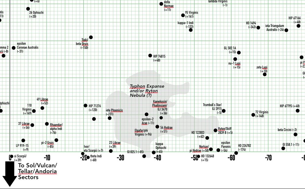
I'm thinking that there should be vertical overlap between the Indus/Ryton Nebula and the Typhon Expanse...?

I don't doubt that this mimics what we saw on-screen. My quibble is with the decisions that resulted in the source material. (The pool table map's grid looks "off", for sure.)
 
I wish that the on-set map had stuck with the Star Charts grid.

I have my own version that I've been working up for Tranquility Press fanfic projects, of course...and I can't help thinking that the Typhon and Indus/Ryton regions could be vertically "stacked" atop each other. I hand-traced the Typhon outline from the source book, and tried to match it to the grid as published.

Of course PIC S3 did something of its own, and I'm trying to reconcile it.

You'll all have your own informed opinions on this.

bafkreido2ja77uiqch5fjxciziwr3jlpgv4hhvxov56vvqwtwsfg76c2gi@jpeg
 
Last edited:
I suspect that stuff has been going on in the neighbourhood of Tiaki/beta Gruis for centuries. Only the professional astronomers can tell us anything, and not all that much so far.
 
If you are not already a member then please register an account and join in the discussion!

Sign up / Register


Back
Top